arcgisjs4加载geoserver的vectorTile
目的
前端使用arcgis for js4 访问GeoServer发布的矢量切片服务。
1 arcgis for js4 加载它并在地图上展示
全部代码
import VectorTileLayer from "@arcgis/core/layers/VectorTileLayer.js";

const lconfig = {
  layerId:'2',
  name: '测试_geoserver_vectorTile',
  urlTemplate:'http://xxx.xxx.x.xxx:xxxx/geoServer/gwc/service/wmts/rest/命名空间:图层名test_abc/EPSG:4490/EPSG:4490:{z}/{y}/{x}?format=application/vnd.mapbox-vector-tile',
  // geoserver 上的图层名(不需要带命名空间)
  layerTable:'test_abc',

}

const param = {
  id: lconfig.layerId,
  title:lconfig.name,
  style:{
    id:lconfig.id,
    version:8,
    sources:{
      abc:{
        type:'vector',
        'capabilities':'TileOnly',
        tiles:[
          lconfig.urlTemplate,
        ],
        // initialExtent: tileInfo4490Size512Meta.initialExtent, // 非必填
        // fullExtent: tileInfo4490Size512Meta.fullExtent,       // 非必填
        tileInfo:{
          ...tileInfo4490Size512,
          // format:'pbf',
        }
      }

    },
    layers:[
      {
        id:lconfig.name+'a', //这个可以随便写
        source:'abc',
        'source-layer':lconfig.layerTable, //这个必须是geoserver上的图层名(不需要带命名空间)
        // minzoom:0,  // 非必填  这个只是控制它的显示隐藏
        // maxzoom:24,  // 非必填  这个只是控制它的显示隐藏,还是会去请求18级的tile的,只是不会显示在地图上。
        type: "fill",
        paint: {
          "fill-color": "#00ff00",
          "fill-outline-color": "#ff0000",
        },

      }
    ]
  },
}
new VectorTileLayer(param)
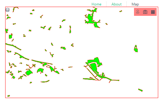
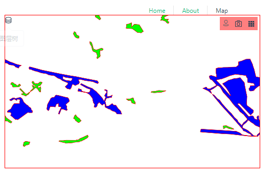
效果
十万个为什么???
1. 阅读VectorTileLayer 文档
网上写的五花八门的。
VectorTileLayer官方文档写的很好,不要一上来就去网上瞎搜!!!
Overview
Overview
How the VectorTileLayer displays is defined by the MapLibre style specification.
VectorTileLayer style information is stored separately from its tiles.
This means that one set of vector tiles may be styled in numerous ways without having to generate a new image cache for each style.
This helps save space and speeds up the process of creating new map styles.
👆矢量切片图层的样式和切片是分开保存的。(也就是切片不包括样式,你要自己写样式)
Creating a VectorTileLayer
Creating a VectorTileLayer
VectorTileLayers may be created in one of three ways: from a URL (either a service URL or a style URL),
an ArcGIS portal item ID,
or a JSON style object.
style
style
A style JSON object of vector tiles that will be used to render the layer.
If initializing the layer with a style JSON object, the tiles are fetched from the tile servers specified in the style object.
它还写了几个创建的例子,看起来from style object像是用的是第三方矢量切片服务。
2. a JSON style object 应该怎么写?
参考1: MapLibre style specification
参考2: ArcGIS Vector Tile Style Editor
const style = {
  // id:configData.id,
  version:8,
  sources:{
    abc:{
      type:'vector',
      tiles:[
        configData.urlTemplate,
      ],
      // initialExtent: tileInfo4490Size512Meta.initialExtent,
      // fullExtent: tileInfo4490Size512Meta.fullExtent,
      tileInfo:{
        ...tileInfo4490Size512,
        // format:'pbf',
      }
    }

  },
  layers:[
    {
      id:configData.name+'a', //Unique layer name
      type: "fill",
      paint: {
        "fill-color": "#00ff00",
        "fill-outline-color": "#ff0000",
      },
      'source-layer':configData.layerTable, //这个必须是geoserver上的图层名(不需要带命名空间)
      source:'abc', // 要和style>sources.abc对应:Name of a source description to be used for this layer. Required for all layer types except background.
      // minzoom:0,  // 这个只是控制它的显示隐藏
      // maxzoom:24,  // 这个只是控制它的显示隐藏,还是会去请求18级的tile的,只是不会显示在地图上。
    },
  ]
}
里面有很多注意的点
怎么拿urlTemplate?
tileInfo?
minzoom,maxzoom,source-layer,source 都是啥?
3. 怎么拿urlTemplate?
1 去geoserver的切片图层 点预览拿请求。

http://xxx.xxx.x.xxx:xxxx/geoServer/gwc/service/wmts?REQUEST=GetTile&SERVICE=WMTS&VERSION=1.0.0&LAYER=命名空间:图层名test_abc&STYLE=&TILEMATRIX=EPSG:4490:{level}&TILEMATRIXSET=EPSG:4490&FORMAT=application/vnd.mapbox-vector-tile&TILECOL={col}&TILEROW={row}
2 去 wmts capabilities找
<ResourceURL format="application/vnd.mapbox-vector-tile" resourceType="tile" template="http://xxx.xxx.x.xxx:xxxx/geoServer/gwc/service/wmts/rest/命名空间:图层名test_abc/{style}/{TileMatrixSet}/{TileMatrix}/{TileRow}/{TileCol}?format=application/vnd.mapbox-vector-tile"/>

<!-- {style} -->
vector tile的样式要自己写,所以这里直接忽略它

{TileMatrixSet}

EPSG:4490

{TileMatrix}

EPSG:4490:0

{TileMatrix}/{TileRow}/{TileCol}

EPSG:4490:{z}/{y}/{x}


<!-- 最终: -->
http://xxx.xxx.x.xxx:xxxx/geoServer/gwc/service/wmts/rest/命名空间:图层名test_abc/EPSG:4490/EPSG:4490:{z}/{y}/{x}?format=application/vnd.mapbox-vector-tile
3 总结
参考:ArcGIS for JavaScript 加载 GeoServer 矢量切片服务
这个参考里用的urlTemplate是通过geoserver预览拿的,使用的时候会报错,无法解析{z}
他认为是版本问题,且换了arcgis for4的版本有成功,有失败。
我根据他的操作换了一个版本,还是无法加载成功。
所以我用的 capabilities里找的url 很丝滑。
4 tileInfo?
放的位置?
我看了 style文档的style.sources中并没有tileInfo属性。
我看 VectorTileLayer文档有tileInfo这个属性。
我尝试把tileInfo拿出来,报错!
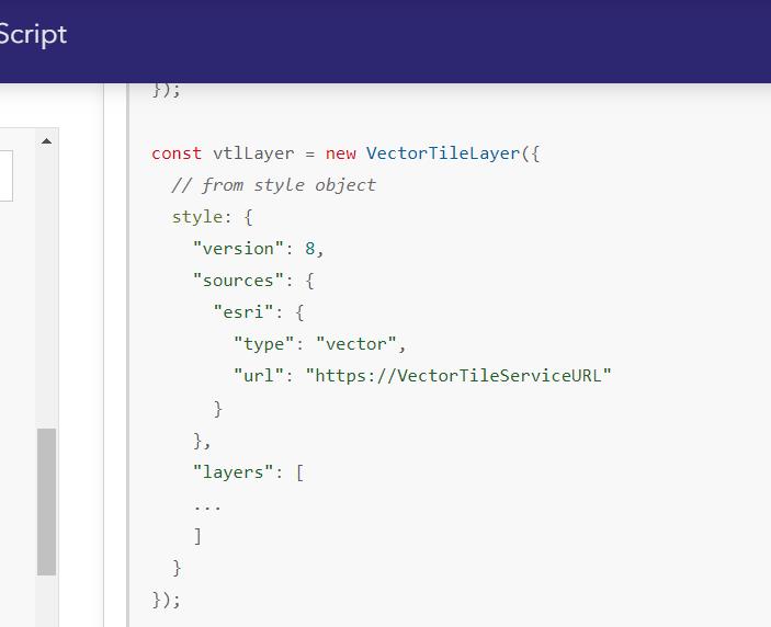
new VectorTileLayer({
  id:'id',
  title:'title',
  tileInfo:{
    // ...
  },
  style:{
    // ...
  }
})
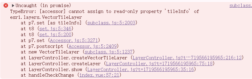
所以它还是老老实实放到style.sources里吧。
256还是512?
用256会导致位置偏移。
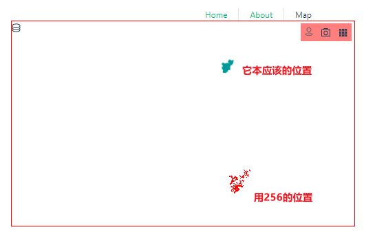
为什么一定要512?
我全网搜索了....
参考:arcgis的create-vector-tile-index
Existing—The tiling scheme from an existing vector tile service will be used. Only tiling schemes with scales that double in progression through levels and have 512-by-512 tile size are supported. You must specify a vector tile service or tiling scheme file in the tiling_scheme parameter.
参考:What is the expected size of a single Mapbox Vector Tile in Pixels?
👆还给你计算的公式.
World_Topo_Map (MapServer)
参考:00252: Tiling scheme is not supported for vector tile layers
5 style中的其它属性?
minzoom,maxzoom
非必填
只是控制图层在底图上的显示隐藏。
minzoom级以下不显示, maxzoom以上不显示。
放大缩小地图的zoom,它还是会去请求某级的tile的,只是不会显示在地图上。
6 调整它的样式?
根据图层的某个字段来设置不同的颜色?
fill-color写成数组的样子。
const style.layers = [
  {
    id:configData.name+'a', //这个可以随意写
    type: "fill",
    paint: {
      // "fill-color": "#00ff00",
      "fill-color":[
        "match",
        ["get", "DJ"],
        "小1型","#ff0000",
        "中型", "#00ff00",
        "大型", "#0000ff",
        "#cccccc" // 默认填充颜色

      ],
    },
    'source-layer':configData.layerTable,
    source:'abc',
  }
]
参考
ArcGIS JS 4加载第三方矢量切片
Is it possible to add vector tile layer published by GeoServer layer using ArcGIS JS API?